Services
About Cholderton
Information about Cholderton
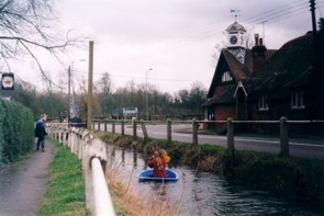
The core of the village lies on the A338, but a dispersed settlement pattern lends a scattered feel to the community. The civil parish comprises 79 properties with 160 on the electoral roll (civil). Overall the population amounts to about 200, though only a small proportion is children. The retired and middle-aged dominate the population, many with connections with the Armed Forces. The numbers of inhabitants born and brought up in the village are dwindling and many of the newer residents are commuters, attracted by the frequent train service to Waterloo from neighbouring Grateley and easy access to the A303. Children in the village attend schools in Newton Toney, Amesbury or Salisbury.
The parish of Cholderton covers an area of 686 ha (1695 acres) and is situated in the upper reaches of the Bourne Valley cutting through chalk downland, typical of this part of the Wiltshire-Hampshire border. The Bourne here is seasonal, flowing only during the winter, usually January to April if at all.
A new bridge has been built from the Crown Inn roundabout leading to Grately which some hope will reduce the possibility of the winter Bourne flooding in the future.
The parish of Cholderton covers an area of 686 ha (1695 acres) and is situated in the upper reaches of the Bourne Valley cutting through chalk downland, typical of this part of the Wiltshire-Hampshire border. The Bourne here is seasonal, flowing only during the winter, usually January to April if at all.
A new bridge has been built from the Crown Inn roundabout leading to Grately which some hope will reduce the possibility of the winter Bourne flooding in the future.
The village lies ten miles north of Salisbury and a similar distance west of Andover. The smaller towns of Amesbury, 5 miles to the west and Tidworth an equal distance to the north provide most essential services, including banks, post offices, doctors and shops. Public libraries are available in Amesbury, Andover and Salisbury.
There is good access via the A303, which cuts across the north edge of the parish, to London and the West Country. For those who prefer public transport a regular train service runs to London and Exeter from Grateley Station, 2.5 miles away. A regular hourly bus service (No. 64) to Salisburyand Tidworth is available Monday-Saturday (approximately between 7.30 am and 5.30 pm).
For Wilts and Dorset bus timetables click here. Train information and timetables can be found at South West Trains.
The two main roads crossing the parish reflect older routes. In the 17th century the Oxford -Salisbury road via Hungerford crossed the west of the parish now surviving only as farm tracks. The London – Bridgwater road via Andover and Amesbury crossed the northern part of the parish. This was turned into a turnpike road in 1761 and de-turnpiked in 1871. From 1958 it was part of the London-Exeter trunk road and in 1988 the new dual carriage way was constructed a little north of its old course.
The road linking Cholderton to Salisbury through the Bourne valley was blocked by the imparking around Wilbury House in Newton Toney parish in the 18th century. In 1835 a turnpike road from Swindon and Marlborough to Salisbury was completed and took in alternative routes around Wilbury Park becoming the main route through the Bourne valley to Salisbury. This was de-turnpiked in 1876 and remains the main road today as the A338.
The parish lies entirely on Upper Chalk, but where the Bourne passes through the east side on a north-south alignment it has deposited river gravels and alluvial clay across the flood plain to a depth of about 1 m. Beacon Hill in the north-west corner of the parish rises to c.183 m and the land falls away south-eastwards to the Bourne to below 91 m rising again to c. 100 m to the east of the river.
Edwin barrow notes in 1889 of the geology “The chalk is not rich in fossils. Three Boulder, or ‘Sarsen,’ stones may still be traced. One is in the garden of the Rectory-house, another lies at the gate of the Lower Farm, and the third was broken up for the foundation of the bridge on the road from Amesbury to Grateley built in 1858.” (This bridge was rebuilt in 2007).
Traditionally there had been downland pasture on the higher land in the north and south of the parish with arable on the lower land and meadow beside the Bourne. Today there is still the mixture of arable and pasture but areas are not so exclusively maintained.
There is good access via the A303, which cuts across the north edge of the parish, to London and the West Country. For those who prefer public transport a regular train service runs to London and Exeter from Grateley Station, 2.5 miles away. A regular hourly bus service (No. 64) to Salisburyand Tidworth is available Monday-Saturday (approximately between 7.30 am and 5.30 pm).
For Wilts and Dorset bus timetables click here. Train information and timetables can be found at South West Trains.
The two main roads crossing the parish reflect older routes. In the 17th century the Oxford -Salisbury road via Hungerford crossed the west of the parish now surviving only as farm tracks. The London – Bridgwater road via Andover and Amesbury crossed the northern part of the parish. This was turned into a turnpike road in 1761 and de-turnpiked in 1871. From 1958 it was part of the London-Exeter trunk road and in 1988 the new dual carriage way was constructed a little north of its old course.
The road linking Cholderton to Salisbury through the Bourne valley was blocked by the imparking around Wilbury House in Newton Toney parish in the 18th century. In 1835 a turnpike road from Swindon and Marlborough to Salisbury was completed and took in alternative routes around Wilbury Park becoming the main route through the Bourne valley to Salisbury. This was de-turnpiked in 1876 and remains the main road today as the A338.
The parish lies entirely on Upper Chalk, but where the Bourne passes through the east side on a north-south alignment it has deposited river gravels and alluvial clay across the flood plain to a depth of about 1 m. Beacon Hill in the north-west corner of the parish rises to c.183 m and the land falls away south-eastwards to the Bourne to below 91 m rising again to c. 100 m to the east of the river.
Edwin barrow notes in 1889 of the geology “The chalk is not rich in fossils. Three Boulder, or ‘Sarsen,’ stones may still be traced. One is in the garden of the Rectory-house, another lies at the gate of the Lower Farm, and the third was broken up for the foundation of the bridge on the road from Amesbury to Grateley built in 1858.” (This bridge was rebuilt in 2007).
Traditionally there had been downland pasture on the higher land in the north and south of the parish with arable on the lower land and meadow beside the Bourne. Today there is still the mixture of arable and pasture but areas are not so exclusively maintained.
Our Services
- Activities
- Amenities
- Booking Form For Village Hall
- Bourne Valley Magazine
- Cholderton & District Water Company
- Church History
- Defibrillators
- Employment
- Early History
- Gallery
- Local Businesses
- Newspaper Cuttings from the 1800’s
- Notes on the Village History
- Regular Events and Notices
- The church and church life
- The Village Hall
- The Village School
- Village Calendar